
 Duration: 8 Days
  US$1155
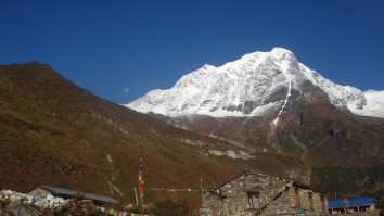
Subscribe Our E-Newsletter
Sign up for Best Deals and Discount. Get News, Notifications and Updates about the recent Events and Offers.
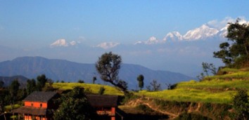
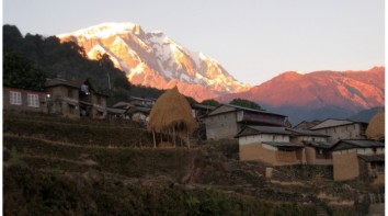
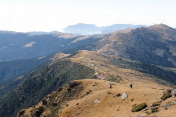
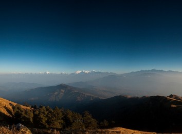
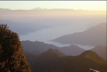
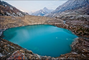
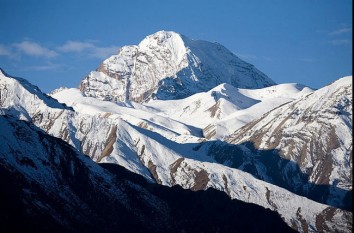
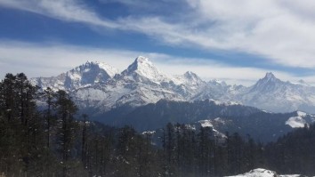
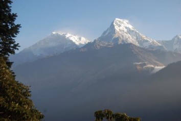
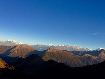
Upper Dolpo Circuit Trekking is one of the most interesting trekking destinations of Nepal for many reasons. First of all, with an area of 7,889 sq. kilometers, it is the largest district of Nepal, and yet one of the most sparsely populated. Its topography is very interesting. It contains the deepest lake of Nepal, Lake Phoksundo, which also happens to be the deepest lake of high altitude in the world. Dolpa is one of the few Nepali districts that is behind the Himalayan mountains, due to which it gets very little rain. Hence, most of the hills are bare with little vegetation. Harsh weather combined with high hills makes this area one of the most inhospitable in Nepal, and yet the barren and majestic hills lend it a rare beauty that is absolutely mesmerizing.
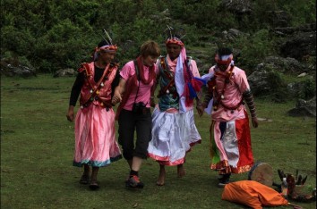
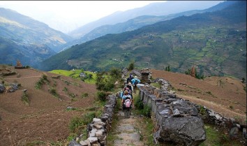
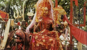
Due to the harsh living conditions, few people live or travel in these areas. As a result, the people of Dolpa are part of a very isolated culture found in specific pockets of northern Nepal. This is a land where life still revolves around horses, mules, and yaks, people still wear traditional attire and jewelry, waters are still divided on the basis of a dice game, and the remains of the dead are given to wild vultures. Even today, much of Dolpa is restricted area for tourists, which contributed to the preservation of unique culture of Dolpa.
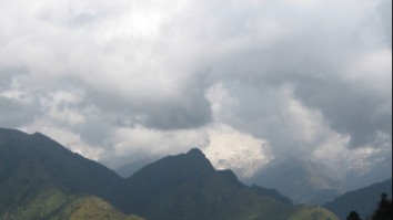
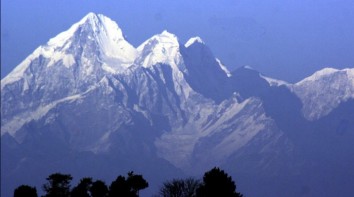
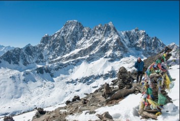
Some of the attractions of this route are: Dho Tarap, a human settlement at the highest altitude in the world, Shey Gumba, religiously the most important Gumba in Nepal, and lake Phoksundo, the deepest lake of high altitude in the world. The months of March to September are good for embarking on this trek. After September, it starts snowing heavily, and trekking is possible only with heavy duty equipment. From November it is completely impassable. The best time is from March to May, as it may rain in June and July.
Upper Dolpo Circuit Trekking Itinerary
Day 01: Arrival at Tribhuban International Airport (T.I.A) and pick up by our private vehicle and transfer to the Hotel.
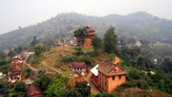
Day 02: Full day guided sightseeing in Pashupatinath, Boudhanath and Patan Durbar Square. (B)
Day 03: The trek starts from Ranjha airport, a small airport on top of the town of Juphal.
Day 04: Chhepka and goes on to several small outposts like Dhane, Kiptarung and Rechi. The road follows the Phoksundo River upstream through dense forests.
Day 05: Trek goes steeply uphill for the first three hours. There is minimal vegetation, and the hills are very dusty in dry seasons. The road offers a bird’s eye view of the unique beauty of surrounding hills.
Day 06: From this onwards we enter Upper Dolpa, as Ringmo village is the boundary between Lower and Upper Dolpa. We started out by walking on a rocky precipice over the Phoksundo Lake.
Day 07: The route is very unique. We crossed Pisten River over and over again without bridges. The river flows inside a gorge, and alternately embraces each side of the gorge.
Day 08: This day was the most arduous day of the trek, since we crossed our highest pass on this day. The road is inclined steeply, interspersed with short stretches of gradual inclines.
Day 09: On this day we crossed the second pass of the journey. From Shey Gumba the path is muddy at first. We walk on the side of a hill on a mild incline.
Day 10: We start this day from Saldang with mild inclines and declines. We walk along a gorge where the bottom is populated with green fields of local barley.
Day 11: On this day we prepared to cross our last pass of. We walked up a mild incline along a river inside a gorge.
Day 12: On this day we crossed the last pass of the journey. The road from High Camp to Jengla Pass is steeply uphill with stones and boulders on the road.
Day 13: From Dho Tarap, we walk in a windy gorge that is almost horizontal. Even though the sun is shining, the wind makes warm clothes necessary on this section of the trail.
Day 14: The trail starts with a mild incline, but takes us to a height of 3,800 meters. The river sets our course as it whistles far below.
Day 15: The track led us through a gentle horizontal walk through dense vegetation. There are lots of village on the way, notably a group of separate villages near each other that are called Tarakot, Tarabagar, Shahar Tara and Tuppo Tara.
Day 16: The last day of the trek led us uphill again. We had to get to Juphal because Juphal is the only city in Dolpa with an airport.
Day 17: Final departure to the airport by our private vehicle. (B)
Arrival at Tribhuban International Airport (T.I.A) and pick up by our private vehicle and transfer to the Hotel.
Full day guided sightseeing in Pashupatinath, Boudhanath and Patan Durbar Square. (B)
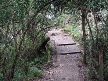
The trek starts from Ranjha airport, a small airport on top of the town of Juphal. Currently, it is the only airport in Dolpa and can be reached from Nepalgunj. The road takes you through a little sojourn in the town of Juphal, after which it descends steeply. For about an hour, the road is muddy and stony with little vegetation. After that, there is a short stretch of motorable road that lasts up to Suligad. Suligad is the entrance to Shey Phoksundo National Park. Here, the tourists who have not paid their entrance fee can do so. Beyond Suligad is restricted area.
From Suligad, the road becomes horizontal, with mild inclines in between. The road is populated with tea shops in between at Khalaripi, Kageni and Sangta. Kageni and Sangta are both ideal lunch places as they have plenty of hotels. Sangta even has a charming campsite with water and toilet facility. The campsite offers a view of the raging Suligad River. Our actual camping was at Chhepka, which is more densely populated than the above mentioned intermediary villages. It also provides campsite and water facility.(B, L,D)
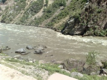
Chhepka and goes on to several small outposts like Dhane, Kiptarung and Rechi. The road follows the Phoksundo River upstream through dense forests. The road inclines mildly uphill at first, and later the incline grows steeper. At some points, the rod dips down to the level of the water. At these points, there is a stone embankment which contains the water and yet lets travelers be close to the water. On this day, travelers cross Phoksundo River several times over small local bridges. At one point between Rechi and Chunuwar, there is a dramatic point where two rivers of distinctly different colors merge to form a single Phoksundo River.
Dhane contains a shop in a tent, where you can buy basic food items. It also contains a trash can and water source. Kiptarung and Rechi also contain tents for basic necessities, and at Rechi a hotel is coming up. The camping is at Chunuwar, which houses a hotel, a campsite, a village water tap and well managed public toilets. It also contains communication facility through a PCO.(B, L,D)
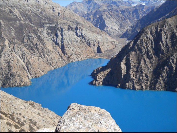
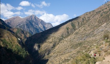
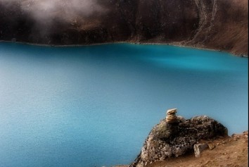
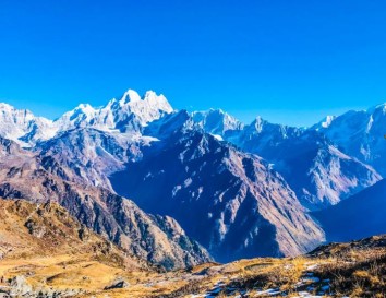
Trek goes steeply uphill for the first three hours. There is minimal vegetation, and the hills are very dusty in dry seasons. The road offers a bird’s eye view of the unique beauty of surrounding hills. These hills are made almost entirely of gray stone with little vegetation. The bare outcroppings have jagged tops, which lead their majestic beauty to the beauty. At the end of three hours of uphill climb is a view tower, where travelers can rest. The view tower offers a view of Phoksundo falls, a spectacular 3-step waterfall that drops down 167 meters from the Phoksundo Lake. After a ten minute walk uphill from the view tower, the travelers can get the first glimpse of Phoksundo Lake. After that, the road goes gently downhill and the view of Phoksundo Lake gets clearer. After walking for about an hour, one arrives at the village of Ringmo. This village of mainly Buddhist people lies on the banks of Phoksundo Lake.
We camped at Phoksundo Lake after only half a day of walking in order to enjoy the beauty of this lake. There is plenty of open space to camp beside the Phoksundo Lake, and also public toilets. The village offers a PCO and electricity to charge mobiles. The Phoksundo bank also offers a spectacular view of Numala Bagala passes which are on the way to Dho Tarap.(B, L,D)
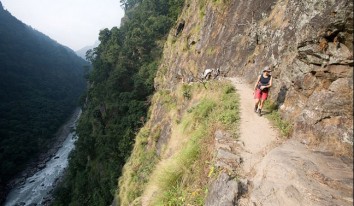
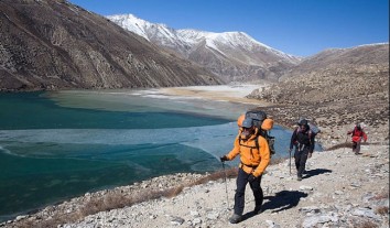
From this onwards we enter Upper Dolpa, as Ringmo village is the boundary between Lower and Upper Dolpa. We started out by walking on a rocky precipice over the Phoksundo Lake. The precipice offers different angles to view all three corners of Phoksundo Lake. The precipice is also the site of a dramatic scene in the popular French movie Himalaya. The road climbs and dips to the level of the lake, where we crossed several shallow streams on foot. We encountered many streams that empty into the Phoksundo Lake. After walking for about two hours, the road swerves to the left, after which the first corner of Phoksundo is obscured from view and we only get to see the last corner. The track goes up to a height of 4,085m, after which it steadily descends through a dense pine forest. After walking downhill for about two hours, we got to Choklapuk, a lovely beach perfect for camping. Located on the edge of Phoksundo’s corner, this place offers a wide expanse for resting and relaxing, and a wonderful view of Phoksundo Lake and surrounding mountains.
After lunch, we walked horizontally along a gorge with mountains on both sides. This was one of the most adventurous parts of the trip. This road is flooded in summer and we walked through ice cold water and among thorny bushes. The river is ice cold, because it descends directly from the Himalayas, and is the major source of the waters of Phoksundo Lake.
Camping was at Ruktang, an open space beside the river. On the left side, this place offers a view of Mt Kanjirowa on clear days, which is full of snow even in the month of July.(B, L,D)
The route is very unique. We crossed Pisten River over and over again without bridges. The river flows inside a gorge, and alternately embraces each side of the gorge. As a result, we have to either walk through the river or due to which we have to walk on the dry side. The walk is uphill but not steep. The water ranges from shallow to knee deep, and the current is very swift. Sandals are recommended for entire day. Several waterfalls fall into the river from both sides.
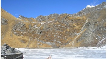
On this day, we climbed up to a height of 4,677 meters. Although this is a considerable height where altitude sickness usually takes hold, this day the cold water alleviated the symptoms of altitude sickness. The lunch was packed this day, because the geography was not very suitable for cooking. Camping was at Base Camp, on the shore of the river. There is a wide open space at the river shore, with stony ground and thorny juniper bushes.(B, L,D)
This day was the most arduous day of the trek, since we crossed our highest pass on this day. The road is inclined steeply, interspersed with short stretches of gradual inclines. The final few hundred meters are in a sandy mountain, where our feet slid at every step. Altitude sickness may take hold at this point, and travelers should be well prepared for that.
After crossing the pass, the other wide offers a spectacular view of light sand colored mountains. The monsoon rains in Nepal come from clouds which travel northwards from the oceans in the south. But most of them disperse their water in Southern Nepal, as they cannot cross the tall Himalayan mountains. Hence, some places in Nepal which are behind tall mountains do not get much rainfall. Dolpa is one of them. The results of little moisture can be seen in these parts, where the mountains are bare and sandy, and the vegetation is very sparse.
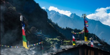
We had packed lunch on this day. After walking downhill from the pass for about four hours, we get to Shey Gumba. From a religious point of view, Shey Gumba is considered the most important of all Gumbas in Nepal. It is almost a Mecca for Buddhists. Though the building itself is modest, the statues in the Gumba are very expensive, some of them are coated in gold and silver. They word Shey itself means “biggest of all” in Tibetan. (B, L,D)
On this day we crossed the second pass of the journey. From Shey Gumba the path is muddy at first. We walk on the side of a hill on a mild incline. There are also some stretches of steep incline. After walking for about three hours, we get to a gorge with a shallow river. We walk uphill along the river shore, then we climb a short stretch of steep incline. The final stretch takes us almost horizontally on a dark, sandy mountain.
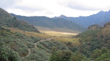
After crossing the pass is a steep downhill trail. Though the hills are barren without greenery, there are all kinds of wildflowers in red, yellow, pink, and blue sprouting from rocky surfaces. We follow a river downstream, and we see more and more barren rock like hills. Lunch was at Namgung, a small village that offers an open brick kitchen for trekkers. If the travelers are weary, they can camp at Namgung instead of walking four more hours to Saldang, as Namgung offers a good camping facility as well.
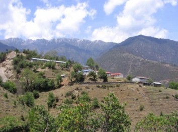
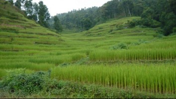
After walking uphill from Namgung for two hours, we reach a hilltop that offers a panoramic view of light green colored mountains far into the distance. We descend from the hilltop to the village of Saldang. Saldang is a beautiful valley, its green fields in stark contrast to the bare hills around. Saldang is densely populated compared to the surrounding hillsides. It is a fertile valley which grows potatoes, rice, wheat, and barley. Saldang also has a primary school, a health center, and communication facility through Hello network. It has a good campsite and running water as well.
Saldang contains a Gumba called Samiye Choying Gumba. This Gumba is older than Shey Gumba, and has been modeled on the Potala Gumba in Tibet and other Gumbas in Thimpu. It has been recently repainted for the festival. The Gumba officials have decided to retain old style stone roofs, instead of giving it a tin roof, so as to preserve its original look.
Alternative: This is a very long stretch to complete in a single day, and it can be broken down at Namgung. Lunch can be packed and camping can be done at Namgung. (B, L,D)
We start this day from Saldang with mild inclines and declines. We walk along a gorge where the bottom is populated with green fields of local barley. We pass several villages on the way, and the mountainside is dotted with little chhortens, or Buddhist shrines. Many of them are hard to access. Lunch was at Namdo, a small village with a school and communication facility. We had to cross a knee deep river twice to reach the camping spot. The campsite was at a river shore a few miles out of Rhakyo. It was on open ground on a small precipice overlooking a river. Thorny juniper bushes were the only vegetation.
This part of our trek is part of a trade route to China. There were many caravans of yaks, horses, and mules going to China. The Tibetan border opens for 15 days each year, during which people in the northern villages of Nepal go to Tibet and shop. They buy merchandise, clothes, and other necessary items, and much of the Yarsagumba trade takes place through this route.(B, L,D)
On this day we prepared to cross our last pass of. We walked up a mild incline along a river inside a gorge. We crossed the river at some points. For a long stretch, the track was almost horizontal along a river shore, but towards the end, the incline became steeper. On this day we left valleys and villages behind, and the scene went back to barren hills with a few signs of vegetation here and there. Lunch was at a height of 4,427 meters. Camp was at High Camp, at a height of 4,850 meters. This was our highest camp of the journey. Even in the month of August, this place was very cold and foggy. This was our coldest camp of all.
On this day we crossed the last pass of the journey. The road from High Camp to Jengla Pass is steeply uphill with stones and boulders on the road. Since we camped at a great height, in the morning we were able to cross the pass very soon, at about one and a half hours. The road going down from the pass is gradually descending at first, and then becomes almost horizontal. On the left are barren ridged hills that look as if they are carved out of individual rocks. Each ridge in the hills is of a different color, red, ochre, or green. They look like parallel waves from afar. On the right, where we walk, there is more greenery. A river, which will later join the Bheri, flows in between.
Lunch was at Takshi, a little village in a broad valley. The valley is very beautiful with lots of yellow wild flowers, and fields of local barley. There were a few houses and tents. About an hour from Takshi is Dho Tarap, where we camped. Dho Tarap is the world’s highest human settlement 4,090 meters. The people of Dho still follow traditional culture, and the houses are built according to traditional architecture where most of the living space is underground, and a small part of the house juts above ground. Dho Tarap is a junction from where roads diverge to Jomsom, Mustang, and Tibet. Hence, we would see a lot of horse, mule, and yak traffic around Dho Tarap. (B, L,D)
From Dho Tarap, we walk in a windy gorge that is almost horizontal. Even though the sun is shining, the wind makes warm clothes necessary on this section of the trail. We follow the same rive as yesterday. We walk on a high, bare precipice and watch the river pass through narrow gorges. The river constantly changes shape, becoming wide and shallow in some places and deep and narrow between close set hills. Sometimes it even disappears between and under the hills. There are ridged hills on both sides. We encountered a couple narrow valleys with a few tents. We also passed several open spaces which were junctions for horses and mules to rest or pass the night. Lang and Tol Tol were two of these junctions. Lunch was at Lang. Camping was at Tangum, a meeting point of two rivers. (B, L,D)
The trail starts with a mild incline, but takes us to a height of 3,800 meters. The river sets our course as it whistles far below. From this day we see growing vegetation. The pine forests go from scarce to dense in a matter of hours, and there are two spectacular waterfalls on this stretch of the road. This stretch of the road is very cold due to the wind. Also, the gorge is made up of almost perpendicular hills, which allow for only a few hours of sunlight.
After descending from the height of 3,800 meters, we came to Laini Odar, a narrow valley with a tent. We had lunch there. Camp was at Lashikyap, a large village on a precipice overlooking the river. The river that we followed was joined by another river to form Thuli Bheri. Thuli Bheri becomes a large and fast flowing river that offers numerous possibilities. (B, L,D)
The track led us through a gentle horizontal walk through dense vegetation. There are lots of village on the way, notably a group of separate villages near each other that are called Tarakot, Tarabagar, Shahar Tara and Tuppo Tara. From Tarakot we walk along the shore of the river. The road sometimes climbs to the top of the hill, and sometimes dips to the level of the river. Lunch was at Shahar Tara, one of the intermediary villages which was directly on our way. Camping was at Dunai, the headquarters of Dolpa, a large town with electricity, health center and communication facility. (B, L,D)
The last day of the trek led us uphill again. We had to get to Juphal because Juphal is the only city in Dolpa with an airport. The road from Dunai is a wide motorable road up to Kalagauda. We walk on this road horizontally for approximately two hours. Then there is a steep uphill stretch for about two hours, as Juphal is situated at a considerable height than Dunai. Finally, we arrive at Juphal airport on top of town. From here we can take a plane to Nepalgunj or Surkhet.Rest of the time for shopping (B)
Final departure to the airport by our private vehicle. (B)
Enjoy the popular trekking and tour packages in Nepal Himalayas. 2024.


Sign up for Best Deals and Discount. Get News, Notifications and Updates about the recent Events and Offers.
© 2011 - 2024 All rights reserved. Madhav Prasad Pandey Developed By : Xenatech Nepal